Shopping for a waterfront lot on the Northern Neck can feel thrilling and confusing at the same time. You picture a dock, sunrises over the Bay, and easy boat days, but the shoreline vocabulary and permits decide what you can actually build, use, and insure. In this guide, you’ll learn the key terms, the agencies that regulate shoreline work, and the practical steps to protect your budget. You’ll also get a clear checklist tailored to Northumberland County and nearby Northern Neck localities. Let’s dive in.
Key waterfront terms you must know
Riparian vs. littoral rights
When you buy along moving water like a river, you typically have riparian rights. On still or tidal waters like the Chesapeake Bay and its tidal rivers, you deal with littoral rights. On the Northern Neck, most shorelines are tidal, so your rights relate to access and reasonable use of the water, subject to state rules and the public trust. Your rights do not guarantee exclusive control of the water itself.
Mean high water and mean low water
Tidal boundaries matter. The mean high water (MHW) and mean low water (MLW) lines help define where private ownership ends and state-controlled submerged lands begin. Your deed and survey should show which tidal line applies to your lot. These lines guide dock placement, shoreline work, and how far any structure can extend.
Accretion, erosion, and avulsion
Shorelines change. Accretion is a gradual build-up of soil that can enlarge usable land over time. Erosion is gradual loss of land due to wind, waves, and storms. Avulsion is sudden loss or gain from a major event. These processes impact how you use the land and may affect insurance and permitting, even if legal boundaries do not shift right away.
Public trust and navigation
Virginia holds public interests in the beds of tidal waters and navigable waterways. You can often build a private pier if permitted, but structures cannot block navigation or interfere with public use. Expect limits on dock size, length, and location, especially near channels or neighboring piers.
Easements and shared access
Not every “waterfront” lot includes private deep-water access. Some neighborhoods use recorded easements for shared docks, paths, or beaches. Confirm whether your deed shows shoreline easements, riparian access easements, or rights-of-way to community facilities. Read HOA or community rules before you plan a dock or lift.
Permits and shoreline work in the Northern Neck
Who regulates what
- Virginia Marine Resources Commission (VMRC): Permits private piers, community docks, moorings, and many structures extending into tidal waters. VMRC also coordinates tidal wetland protections.
- Virginia Department of Environmental Quality (DEQ): Oversees Chesapeake Bay Preservation Act implementation and certain water quality authorizations and wetlands-related reviews.
- U.S. Army Corps of Engineers (USACE): Reviews work in navigable waters and dredge-and-fill activities, often through nationwide permits.
- Northumberland County Planning and Zoning: Applies local setbacks, floodplain rules, and Chesapeake Bay ordinance requirements.
- Virginia Department of Health (VDH): Reviews onsite sewage (septic) suitability and setbacks near shorelines.
- FEMA: Produces flood maps and sets standards that influence local floodplain rules and insurance requirements.
Docks, piers, and ramps
Most private docks and ramps in tidal waters need VMRC permits and may also require USACE review. Your design must respect navigation and neighbors’ riparian areas. Length, height, and location are reviewed, and permits often require notice to adjacent owners.
Bulkheads vs. living shorelines
Traditional bulkheads and seawalls can protect property but may harm natural shoreline function and are increasingly scrutinized. Living shorelines use native plants, sills, and strategic grading to reduce erosion and improve water quality. They still require permits but are often more favorably considered when conditions fit the design.
Tidal wetlands and dredging
Work in tidal wetlands is tightly regulated. Even minor fill or grading can trigger state and federal review. Dredging or creating a boat basin requires extensive review, potential mitigation, and coordination among VMRC, USACE, and DEQ.
Chesapeake Bay Preservation Areas and buffers
Virginia’s Chesapeake Bay Preservation Act requires localities to protect water quality with buffer rules and development limits near tidal shorelines and wetlands. In Northumberland County, these rules often designate Resource Protection Areas (RPAs) with vegetated buffers that limit clearing, grading, and building placement. Expect setbacks and vegetation requirements that affect house location, outbuildings, and septic.
Practical constraints that shape use and cost
Flood zones and FEMA requirements
Many Northern Neck waterfront lots fall in FEMA Special Flood Hazard Areas. If your future home sits in these zones, lenders may require flood insurance, and the county will set elevation and construction standards. Ask for the FEMA flood map panel and consider an elevation certificate to understand building height and insurance implications.
Insurance and financing
Flood insurance costs depend on structure elevation, design, and risk. Elevated designs and floodproofing can reduce premiums. Some private insurers limit coverage options in high-risk zones, so plan early with your lender and insurance provider to avoid surprises.
Septic, wells, and utilities
Rural waterfront lots often rely on septic and well water. VDH rules govern soil suitability, setbacks from the water and wetlands, and replacement area requirements. Alternative systems may be needed on tight or marginal sites. Confirm utility access for electric and telecom, since extending service can raise project costs.
Erosion, sea-level rise, and upkeep
The Chesapeake Bay region experiences sea-level rise and land subsidence, which increase erosion and tidal flooding risks. Budget for ongoing shoreline maintenance, dock repairs, and access road upkeep. Review historic permits or stabilization work to estimate future needs.
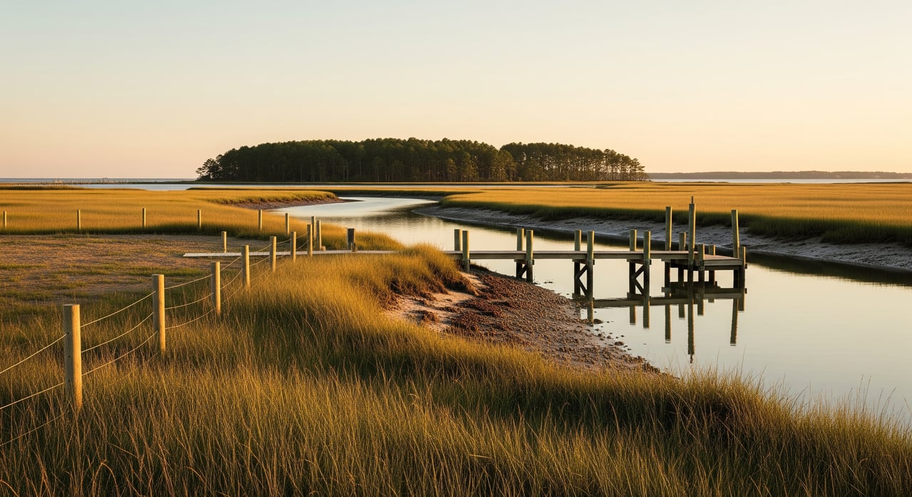
Navigation and boat access
Depth, tidal flats, and nearby channels determine where a dock can go and whether dredging is feasible. Neighboring piers, mooring fields, and local traffic patterns also shape safe access. A site visit at both low and high tide helps you gauge real-world use.
Northern Neck due diligence checklist
Documents to request
- Recorded deed and plat, noting whether the boundary extends to the tidal line and any language on riparian rights.
- Full title report and a stamped survey showing MHW and MLW, structures, encroachments, and easements.
- Site-specific topographic map with elevations, flood elevations, and likely building envelope.
- FEMA Flood Insurance Rate Map panel and any existing elevation certificate.
- Permit history for docks, bulkheads, dredging, or shoreline stabilization.
- Septic permits and records, soil tests, and maintenance history.
- Utility service records and the location of lines or any offshore cables or pipeline easements.
- HOA documents or covenants affecting docks, mooring, or shoreline use.
- Recent shoreline surveys or reports on accretion, erosion, or contested boundaries.
- Environmental assessments or wetland delineations if prior work occurred.
Questions to ask the seller
- What tidal boundary is shown on the survey and deed, and where is the MHW line today?
- Is there an active VMRC or USACE permit for a dock, and is it transferable?
- What shoreline stabilization has been done, and were permits obtained?
- When was the septic last inspected, and are there constraints on replacement areas?
- Have there been flood or storm-related insurance claims?
- Are there recorded easements for beach or dock access, including shared facilities?
- Are there navigation or shoaling issues that affect regular boat use?
Local pros and offices to contact
- Licensed land surveyor experienced with tidal boundaries and waterfront plats.
- Local real estate attorney familiar with Virginia riparian rights and easements.
- Title company with tidal lands experience.
- Licensed marine contractor or coastal engineer for dock feasibility and shoreline stability.
- Environmental consultant for tidal wetlands, living shoreline design, and permit support.
- Northumberland County Planning and Zoning for setbacks, floodplain rules, and Chesapeake Bay ordinance details.
- Northumberland County Health Department or VDH for septic approvals.
- VMRC regional office for pier and tidal wetlands permitting guidance.
- USACE for navigable waters and dredge-and-fill requirements.
- Flood insurance specialist to model premiums and elevation strategies.
How to use these terms in your offer
Apply the vocabulary and checks before you write an offer. Tie your timeline to permit and feasibility milestones, and make sure your survey references MHW and MLW. Confirm septic feasibility and RPA limits early, then price in realistic shoreline and flood mitigation. This approach helps you protect value and avoid delays after closing.
If you want a clear, local plan tailored to a specific Northern Neck lot, reach out for a consult. Our team can help you frame the right questions, review the survey and deed, and connect you with the right pros so you move forward with confidence. Start your strategy with Michela Worthington.
FAQs
Do Northern Neck waterfront buyers own the beach and water in front?
- Ownership depends on the deed and the tidal boundary on your survey. Many owners hold to the mean high water line, while Virginia maintains public trust interests in tidal waters.
Can I build a private dock on a Northumberland County lot?
- Possibly, but you typically need VMRC approval and sometimes USACE review. Local setbacks and neighbors’ riparian areas also affect size and location.
How do FEMA flood zones affect a waterfront build?
- If your home site is in a Special Flood Hazard Area, lenders may require flood insurance and the county will set elevation and construction standards for permits.
What should I know about septic on a tidal lot?
- VDH rules control soil suitability, setbacks from waterways and wetlands, and replacement area requirements. Some sites need advanced or alternative systems.
Who approves bulkheads or living shorelines?
- Shoreline stabilization often involves VMRC, DEQ, and possibly USACE. Living shorelines are encouraged where conditions are suitable and still require permits.
What long-term risks should I account for on the Chesapeake Bay?
- Erosion, storm surge, tidal flooding, changing buffer rules, and insurance costs. Review historic shoreline change and plan for ongoing maintenance and elevation needs.